“We boarded the steamer all happy and gay, and got off in Seward the nineteenth of May,” according to Shorty Gustafson in his folksong Cheechako about newcomers to Alaska. Back when Shorty traveled by steamboat, many vessels didn’t make it to their destinations. Thousands were lost around the nation’s coasts including a Bering Sea crab boat that put out a mayday one very cold, stormy night back during my time aboard the buoy tender Ironwood. We had made an emergency repair to the vessel’s shaft coupling in Dutch Harbor the night before and advised the captain to arrange a permanent repair before going fishing. He didn’t follow our advice.
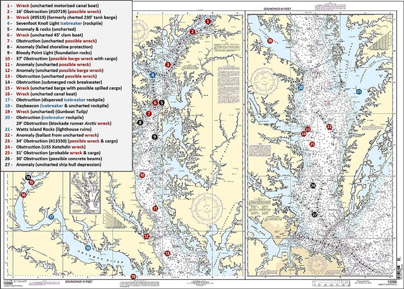
The Chesapeake Bay and its tributaries were (and are) no exception to marine casualties. Just check Coast Survey’s online Automated Wreck and Obstruction Information System (AWOIS) map viewer and see for yourself. The risk of maritime casualties continues, although with less frequency, and the collapse of the Francis Scott Key Bridge from a ship strike with tragic loss of workers on the bridge is a shocking reminder that bad stuff happens. But our fishing story is about what happened farther back in the past. The potpourri of wrecks and obstructions shown on Chart 1 illustrate what to look for.
Some known wrecks aren’t charted because their exact position is unknown, they’re covered by sediment, or they aren’t considered a danger to navigation. A select few aren’t charted due to archeological and historic preservation concerns (hence no coordinates for them in the following text). For example, a known uncharted wreck marked in general as Site 1 lies between the Chesapeake and Delaware Canal and Pooles Island. It’s thought to be the remains of the wooden vessel A. Woodall that burned in December 1924 during a winter transit, with the loss of the entire crew. The bulwarks of this low-profile wreckage match a long, narrow canal boat configuration.
Site 2 marks a 16’ least-depth obstruction northwest of Howell Point, west of the ship channel at coordinates 39°22.911 x 76°07.094. It was found during a National Ocean Survey (NOS) 1999 hydrographic survey. Although charted as an obstruction, the configuration suggests a wreck. There’s also anecdotal information that this was a paddle-wheeler which burned to the deck and sank. Boiler explosions and fires were a significant threat back in the days of steamboats.
Site 3 marks the location of a sunken 230’ fuel barge at reported coordinates 39°12.807 x 76°15.981, with a least depth of 10’. The barge grounded in 1980 and sank 10 years before the Gales Lump Fish Haven was established. NOAA accepted the survey team’s recommendation to remove the barge as a charted wreck since it was by then inside the fish haven. Although consistent with charting protocols for fish havens, the deletion resulted in the wreck being lost to common knowledge.
Site 4 is a rock icebreaker that covers and uncovers which protected the former Seven Foot Knoll lighthouse from winter ice. Charts show a riprap symbol which means rocks are there, but not necessarily around the light structure. Electronic charts don’t always include this symbol although in some cases rocks are charted. These rocks are northeast of the light tower at coordinates 39°09.320 x 76°24.537.
About 1200 yards north northeast of the Bay Bridge (Site 5, Chart 2) just west of the old riverbed, look for scattered rocks and an anomaly at coordinates 38°59.898 x 76° 21.094W. It could possibly be a mostly buried, broken up wreck, or it could be an elongated outcropping.
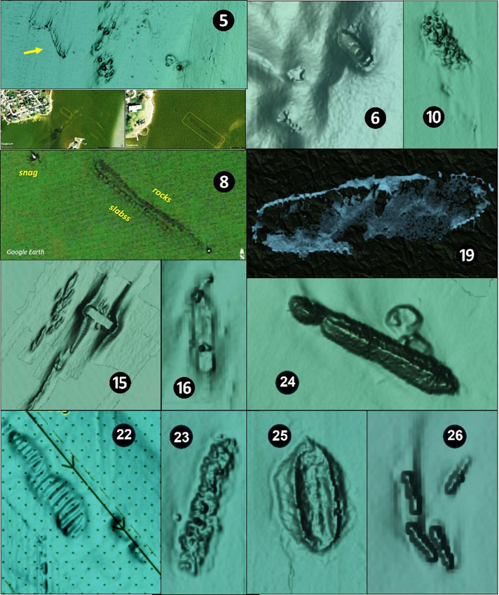
An uncharted wreck is nestled on the edge of the Sandy Point Shoal at coordinates 39°00.156 x 76°23.462, Site 6. Depths drop from 15’ to 24’. This feature looks like a rugged knob along the shoal’s northeast corner until zooming in; the wreck is about 40’ to 50’ long with the stern in a scour. Anecdotal information is that it was a clam boat. There are also two small obstructions immediately to its southwest.
Site 7 is an uncharted obstruction that’s possibly a wreck at coordinates 38°57.717 x 76°25.110. Site 8 is what appears to be a failed 125’ long shoreline protection structure at the entrance to Ramsey Lake. Charted as a lowland islet at coordinates 38°54.312 x 76°29.659, it’s actually a submerged double line of slabs and rocks revealed by crosschecking with satellite imagery using Google Earth. The feature is one of the many nearshore spots covered in “West Side Story,” FishTalk Magazine (April 2023). Site 9 marks Bloody Point Light. Efforts were made to stabilize the bottom for lighthouse construction with mats and rocks. So, if you snagged while jigging, you may have hooked into what is now scattered rock.
Just east of Plum Point Fish Haven at coordinates 38°37.080 x 76°28.539, is another charted obstruction, Site 10, which may be a wreck. Its BAG profile suggests a 200’ long, 35’ wide hull form with the forward half mostly covered in sediment. The back half is covered with objects that could be cargo. Site 11 marks the location of an elongated uncharted anomaly at coordinates 38°27.474 x 76°25.680. Its profile suggests a wreck. Site 12 in the mouth of the Patuxent River marks an anomaly at coordinates 38°18.568 x 76°27.756. Zooming in reveals what appears to be the corner of a mostly buried barge. For features in this area, see “Poking Around the Pax” (March 2024). Site 13 marks another uncharted obstruction, this one at coordinates 38°12.138 x 76°17.776. The elongated profile also suggests a wreck.
Over in the Potomac River, look for a 100-yard-long submerged rock breakwater (Site 14) at coordinates 38°36.636 x 77° 14.706, on the west side of Occoquan Bay (see “Occoquan Bay: An Angling Oasis” (May 2024). Look for an uncharted capsized barge with what could be distributed spilled cargo around coordinates 38°35.274 x 77°14.010 (Site 15). Site 16 is a known but uncharted historic Civil War wreck off Shipping Point. This commandeered wooden canalboat was scuttled by Confederates who were trying to evacuate cannons for the defense of Fredericksburg, but had to abandon their mission when approached by a Union gunboat.
Multiple lighthouses in the middle and lower Potomac River were threatened by winter ice resulting in the placement of icebreaker rockpiles. Some are visible at the surface but some were knocked down and are subsurface, such as the distributed scattered rocks at Site 17, coordinates 38°24.217 x 77°04.894. The former lighthouse now day beacon on Cobb Point Bar has both a visible icebreaker as well as a submerged rockpile, the latter at coordinates 38°14.570 x 76°49.609. These features are detailed in “This Is Potomac River” (Young, 2024).
Site 19 marks another uncharted historic Civil War wreck, this one the Gunboat Tulip. A defective boiler which the captain had fired up for more speed due to the threat of hostile shore fire blew up, killing most of the crew. The remains are still there as shown by side-scan sonar.
Site 20 is the location of yet another subsurface rock icebreaker, this one at the entrance to the Great Wicomico River at coordinates 37°48.249 x 76°16.033. Although rocks are charted, they’re not marked by a warning beacon. This pile collects a boat or three every year (but it’s also a promising spot to check for stripers). Straight out from Taskmakers Creek at coordinates 37°49.460 x 76°12.481 is a charted 29’ obstruction. This is actually the wreck of a sailing vessel with at least one square-rigged mast. Historical records suggest it’s the Confederate blockade runner Arctic, which was boarded and burned.
Look for more subsurface rocks south of Watts Island and 400 yards northeast of Watts Island Warning Light at coordinates 37°46.957 x 76°53.647. There are two rock symbols (Site 21) where the BDV Digital Elevation Models Color Shaded Relief data layer shows mounds. This is actually the ruins of a masonry lighthouse structure, and based on historic pictures, possibly failed riprap and bulkhead shoreline protection. It’s very shallow, but a good fishing spot. Approach with great care.
Look for rocks at Site 22, coordinates 37°39.693 x 76°08.604, in the middle of Rappahannock Shoal Channel halfway between Buoys 57 and 59. By appearance it’s ballast rock that was placed between ribs of a wreck which has disintegrated. Site 23 southeast of Rappahannock Spit marks a 34’ least-depth obstruction at coordinates 37°34.128 x 76°09.863. It rises about five feet off the bottom. The image suggests an upright barge wreck with cargo. Look for a 100 yard long, narrow, eight-foot least-depth obstruction at Site 24 at 37°34.303 x 76°15.026. Based on historical records and profile, this is the “lost” target ship Katahdin. For details, see “Ironclad Reef” (March 2021).
Site 25 marks a 31’ least-depth obstruction at coordinates 37°29.972 x 76°08.210. It’s most likely a sunken scow with a cargo of stone, based on BAG and side-scan sonar images. Look for what appears to be an unofficial artificial reef at Site 26, at coordinates 37°16.564 x 76°10.759. Four elongated objects resembling concrete beams are seen in the BAG image. First found during a 1971 survey covering an area that’s about 100’ long and 30’ wide, it’s located in a dredged material disposal area. A guess is that a vessel depositing dredged material simply dumped unwanted materials overboard.
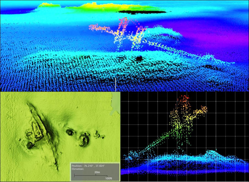
This scouting voyage ends with a non-wreck: what looks like a ship hull form in the middle of the York River Entrance Channel southeast of Buoy “1YR” at coordinates 37°07.463 x 76°09.521. It’s actually a ship-shaped depression. A guess is that a loaded tanker inbound during very low water conditions plowed its way to a stop in soft sediment and later refloated without further mishap.
There’s obviously potential for more structure out there than is charted. Keep an eye on the side-scan and down-looking sonar displays when transiting at speeds where these electronics present good images of bottom features, and if you find an uncharted wreck, avoid anchoring on it and share the coordinates with state historical authorities.
-By Wayne Young
As well as being a regular contributor to FishTalk, Wayne Young is the author of multiple books detailing wrecks and fishing reefs in the Chesapeake Bay, Delaware Bay, and beyond. All are available at Amazon.com, and you can find his Facebook page at “Chesapeake Bay Fishing Reefs.”