Assessing which spot will be productive as tomorrow’s fishing destination is a guessing game and fishing reports from yesterday are yesterday’s report. Fish come, hang around for a while (or not), and go, and environmental conditions are constantly changing. Another complicating factor is that identifying spots can get confusing because some wrecks are known by the same name. Take for example the “flour wreck” at New Jersey’s Barnegat Inlet. Actually, there are two wrecks at Barnegat, one north of the inlet and one south just down the beach. Each was carrying a cargo of flour when they stranded and broke up, and both are known by the same local name. There are multiple “steel wrecks,” “boiler wrecks,” “car floats,” “wood wrecks,” and “China wrecks,” as well. There are also multiple wreck sites that bear the same actual ship names. Take for example the name Mohawk. The U.S. Revenue Cutter Mohawk was lost in New York Bight. A later Coast Guard Cutter Mohawk is now an artificial reef off Florida. The S.S. Mohawk, a large liner, was lost off Manasquan Inlet following a collision. This ship bore the same name as a former liner from the same shipping company. The earlier S.S. Mohawk caught fire and sank in Delaware Bay. I don’t necessarily believe in jinxes, but naming a ship after one lost by the same organization isn’t necessarily a good marketing strategy and could end up pushing fate to the limit.
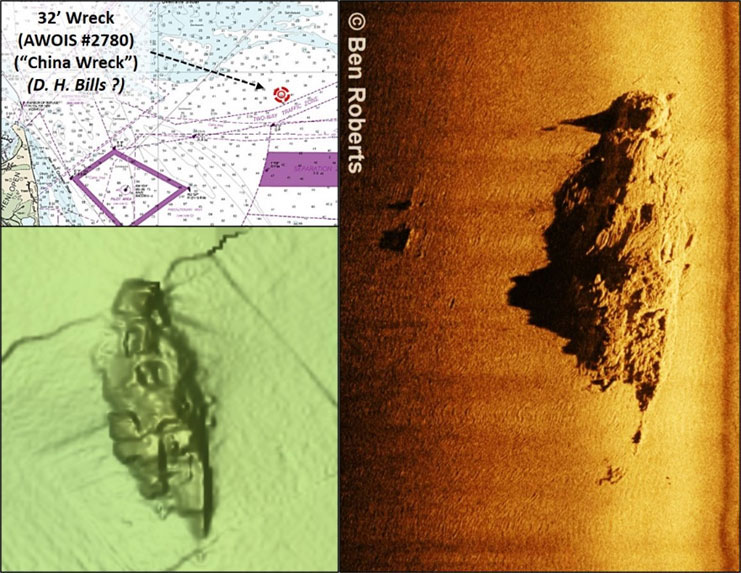
One of the more well-known “China wreck” fishing and diving hotspots is in the ocean approach to the Delaware Bay, not to be confused with the “China wreck” just up the coast at Townsends Inlet. This wreck off the Bay Entrance is within Bathymetric Attributed Grid (BAG) Color Shaded Relief coverage by the Bathymetric Data Viewer (BDV). The image displayed by this National Oceanic and Atmospheric Administration (NOAA) online application was based on multibeam sonar data collected in 2013. The image is somewhat grainy, but still gives a good indication of what’s there. The wreckage is oriented approximately north-south with the bow at the northern end. The site was scanned by wreck detective Ben Roberts during his 2021 Eastern Search & Survey (ESS) offshore wreck hydrographic survey project. In addition to the high-definition scan of this wreck Ben shared with FishTalk included as part of Chart 1, more scans and background information are accessible through the ESS Facebook page.
“Brass spike wreck” is another local name that has been applied to multiple wrecks, one of which is off Ocean City, MD, and the other off the Chesapeake Bay Entrance. Both are popular dive sites. The name “brass spike” is derived from the yellow alloy used by shipbuilders back in the days of sail to hold the ships together. The alloy is probably bronze rather than brass, and held up better than iron spikes. Coordinates for the unidentified wreck off of Ocean City from Gary Gentile’s “Popular Dive Guide Series: Shipwrecks of Delaware Maryland,” 38°17.507 x 74°45.263. Also known locally as the “wood wreck” this one was included in Ben Robert’s 2021 survey project. He found the wreck broken in two main sections spanning about 630’. A third, smaller object is shown about 200 yards west; best guess is that it’s also a broken off fragment from the wreck. The wreckage has been there a long time and is highly deteriorated, but that doesn’t mean there aren’t any fish there. In fact, Ben imaged a huge pile of fish suspended over the wreckage at the southeast end of the site.
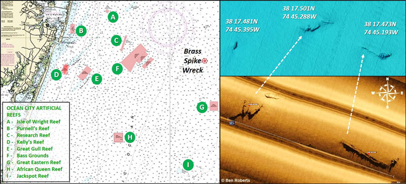
When fishing off of Ocean City there are a lot of other spots to choose from as well, including the Ocean City Reef Foundation (OCRF) reef sites. Captain Monty Hawkins and his Morning Star party boat have been adding materials to the artificial reef system since the late 1990s when Ocean City accepted the reef permits. Reef development there is an ongoing non-profit enterprise that relies on sponsors, donors, and volunteers. Coordinates for the artificial reefs are available from the foundation and all donations go to continued reef development; find out more at ocreefs.org.
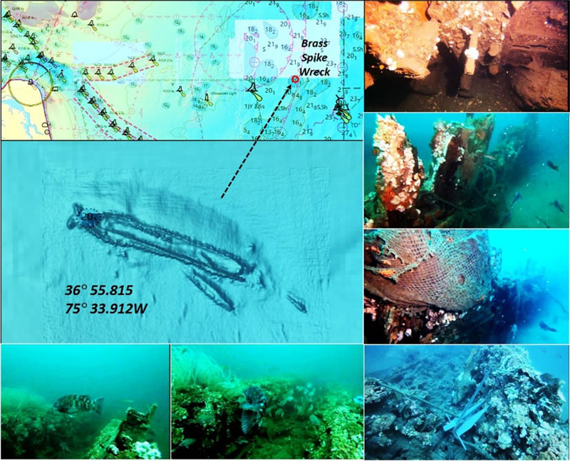
The other “brass spike wreck” is directly off the Chesapeake Bay Entrance at coordinates 36°55.815 x 75°33.912. This wreck is somewhat broken up and lies in a scour hole. As with the Ocean City wreck, this is an older and unidentified wooden wreck. The stills were taken from a video by diver Jerrod K. Jenkins, JKJ Diving, who made them available to FishTalk. The full video is posted on YouTube. (There are other “brass spike” videos on YouTube, most annotated as taken at the Virginia wreck site.) This site is at times covered with fish, as shown, but it’s also festooned with fishnets and is quite rugged so there are a lot of snagging hazards. These wrecks are valuable resources, so let’s respect them and avoid damaging what’s left by anchoring off of them, or using a sacrificial wreck anchor that can be left behind.
-By Wayne Young
As well as being a regular contributor to FishTalk, Wayne Young is the author of multiple books detailing wrecks and fishing reefs in the Chesapeake Bay, Delaware Bay, and beyond. All are available at Amazon.com, and you can find his Facebook page at “Chesapeake Bay Fishing Reefs.”